You can get around Seoul with Lines 1 to 4, but once your schedule gets longer, it becomes much easier when you start using Lines 5, 6, and 7 together.
Popular areas such as Yeouido, Gwanghwamun, Itaewon, Mangwon, Express Bus Terminal, and Gasan Digital Complex are much easier to connect when you understand these lines.
This guide uses the seoul subway map as the base and explains Lines 5, 6, and 7 separately, including where each line is actually useful.
▶ Seoul Subway Line 1 Map, Ticket Buying Methods, and Tourist Apps in One Guide
▶ Seoul Subway Lines 2 3 4 Map and Key Transfer Stations at a Glance
Table of Contents
1. Start with Lines 5, 6, and 7
Inside the Seoul subway system, Lines 5, 6, and 7 serve different roles, so it is easier to read them with different 기준 inside the same seoul subway map.
Line 5 is strong for crossing central Seoul and the Han River east to west, Line 6 is useful for moving through Mapo, Yongsan, and Jungnang areas, and Line 7 is often used for long north-to-south and east-to-west city travel.
When you first look at them, it helps to begin with one question: which parts of Seoul does each line pass through.
| Category | Line 5 | Line 6 | Line 7 |
|---|---|---|---|
| Basic role | Connects the airport-side west with downtown and eastern residential areas | Connects northwest Seoul, Mapo, Yongsan, Seongbuk, and Jungnang | Connects northeastern Seoul to southwest Seoul over a long distance |
| Main point to check | Branch after Gangdong | Direction around the Eungam loop | Long straight movement and transfer hubs |
| Main areas | Yeouido, Gwanghwamun, Dongdaemun area | Hapjeong, Mangwon, Gongdeok, Itaewon area | Express Bus Terminal, Isu, Gasan Digital Complex area |
| Common mistake for first-time riders | Same Line 5 trains may have different final destinations | Same line but confusing travel direction | Need to decide whether you are only reading Seoul or including outer sections |
| Best use case | East-west movement, downtown access | Area-to-area movement, popular neighborhood access | Long daily movement, fewer transfers |
If you think of Line 5 as the downtown and business route, Line 6 as the neighborhood connector, and Line 7 as the long daily travel line, the rest becomes easier to follow.
Seoul city guidance also presents Line 5 around the Banghwa to Gangil and Macheon range, Line 6 as a full-route line, and Line 7 around the Onsu to Jangam range.
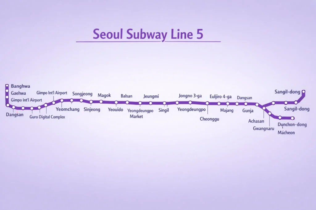
2. Seoul Subway Map Line 5 Sections
On the seoul subway map, Line 5 connects many places people often visit, including Yeouido, Gwanghwamun, Jongno 3-ga, Euljiro 4-ga, and Dongdaemun History & Culture Park, so it is used often in real schedules.
Its west-to-east flow is clear, and as you move farther east, the purpose of travel begins to split into office trips, sightseeing, and residential movement.
| Section | Main stations | Travel purpose | Good to know |
|---|---|---|---|
| Western access section | Banghwa, airport-side connected section | Airport-side and western access | Often read together with the Airport Railroad |
| Key west-of-river section | Yeouido, Yeouinaru | Business district and Han River access | Useful for Yeouido Park or IFC Mall plans |
| Core downtown section | Gwanghwamun, Jongno 3-ga, Euljiro 4-ga | Sightseeing, work, transfers | Convenient for moving to other lines inside downtown |
| Dongdaemun area | Dongdaemun History & Culture Park | Shopping, exhibitions, evening movement | Often linked with Lines 2 and 4 |
| Before the eastern branch | Gangdong | Direction check point | You should check the destination after this point |
| After the eastern branch | Toward Macheon / toward Hanam | Residential movement | Trains are still on Line 5 but final destinations differ |
If you begin around Gwanghwamun, move to Dongdaemun, and then continue into eastern residential areas, Line 5 is one of the easiest lines to use for that full flow.
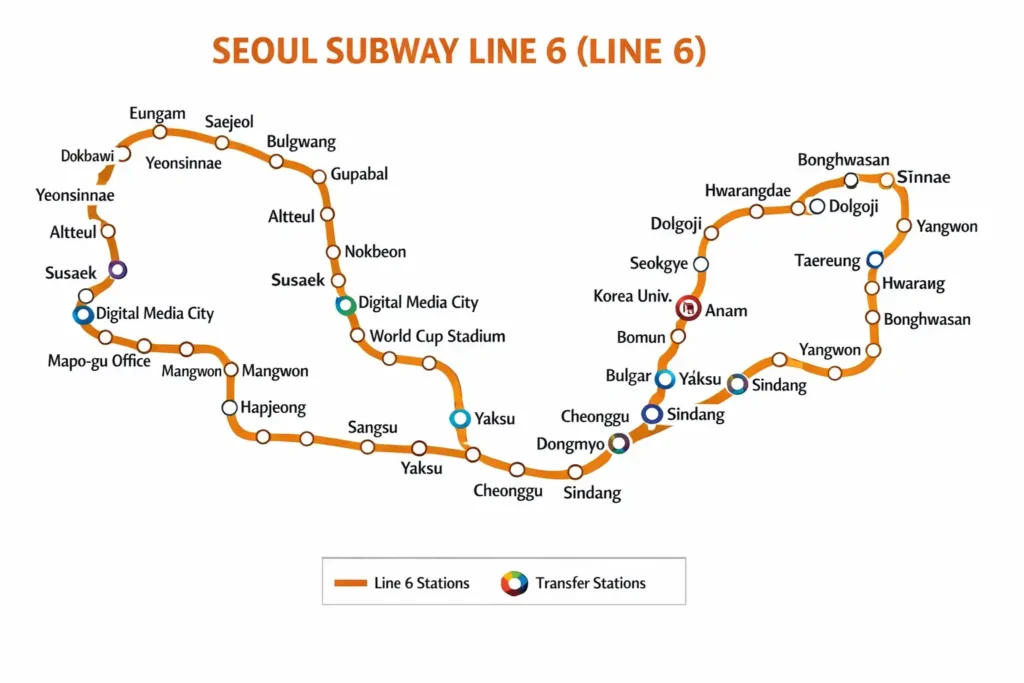
3. Seoul Subway Map Line 6 Direction
On the seoul subway map, Line 6 connects areas such as Hapjeong, Mangwon, Gongdeok, Samgakji, Itaewon, Yaksu, Dongmyo, Korea University, Seokgye, and Taereung, so it mixes sightseeing movement and daily city travel naturally.
This line does not feel like a straight downtown office line. It works more as an area-to-area connector, which becomes more useful when your schedule includes several different neighborhoods.
| Section | Main stations | Main use | What to check |
|---|---|---|---|
| Northwest start | Eungam, Yeokchon, Bulgwang | Northwest daily travel | Check the loop shape first and confirm direction |
| Mapo section | Digital Media City, World Cup Stadium, Mangwon, Hapjeong | Stadiums, markets, Han River access | Different from the Hongdae line flow |
| West-of-center connector | Gongdeok, Samgakji | Work, transfer, Yongsan-side movement | Major transfer zone with several lines |
| Yongsan section | Itaewon | Sightseeing, food, walking | One of the main destinations on Line 6 |
| Northeast connector | Yaksu, Dongmyo, Korea University, Seokgye | Daily movement, university area, transfers | Often useful even for short rides |
| Northern end section | Taereung, Bonghwasan, toward Sinnae | Jungnang area movement | Useful to check before and after long rides |
On Line 6, it helps to check the travel direction first instead of boarding only because the station names look familiar.
The Eungam side can be confusing if you only glance at the map, so checking both the platform board and the next-station display is helpful.
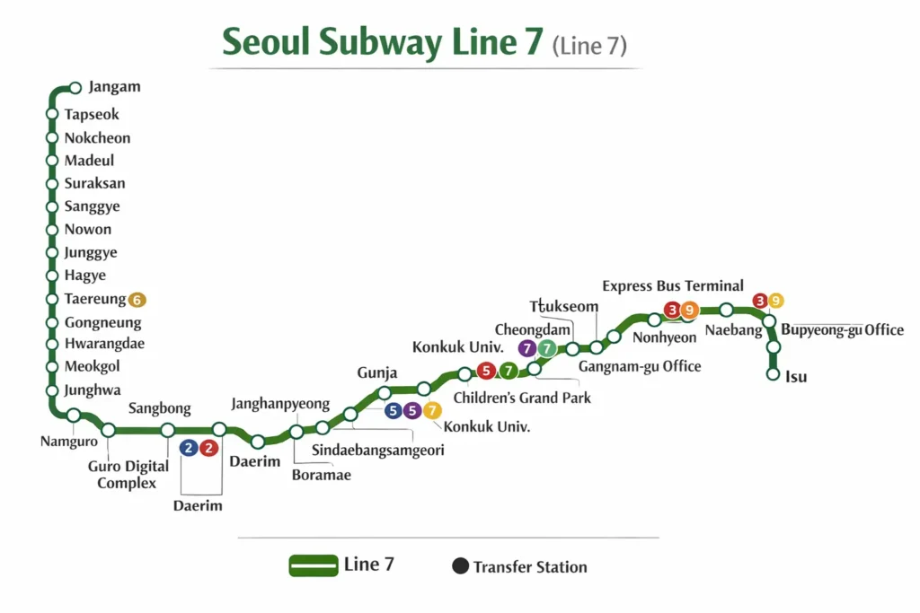
4. Seoul Subway Map Line 7 Points
On the seoul subway map, Line 7 acts as a long corridor from northeastern Seoul through the south and into the southwest, so it is often stronger for long city movement or daily travel than for short sightseeing only.
It is useful for linking eastern residential areas near Konkuk University with Express Bus Terminal, Isu, Soongsil University, Gasan Digital Complex, and Cheolsan in one line of thinking.
| Section | Main stations | Travel role | Real use point |
|---|---|---|---|
| Northeastern start | Jangam, connected northeastern section | Northeast daily travel | Long-distance commuting, hospitals, schools |
| Mid-route connection | Areas near Konkuk University | Eastern area connection | Often compared together with Line 2 access |
| South Gangnam side | Express Bus Terminal, Banpo area | Transfers, shopping, express bus access | Useful for long in-city movement |
| Southwest connector | Isu, Soongsil University Entrance | Residential and university movement | Easy to read together with Line 4 |
| Southwest business area | Gasan Digital Complex | Work, office area, transfers | Check Line 1 connection together |
| Outer extension understanding | Toward Bucheon and Incheon extension | Beyond-Seoul connection | Decide first whether your route stays inside Seoul |
If you need to go from the Konkuk University side to Express Bus Terminal and then to Gasan Digital Complex in one day, Line 7 often gives you a cleaner route than expected.
It is not a circular central line like Line 2, but in many real cases it reduces transfer count and keeps the route simpler.
Seoul route materials and extension-opening information also show that Line 7 is no longer only a Seoul line and continues toward Bucheon and Incheon.
5. Seoul Subway Map Transfer Stations
When reading Lines 5, 6, and 7 together, it is much more practical to find the main transfer hubs first on the seoul subway map than to focus on the total number of stations.
| Transfer station | Connected lines | Main use | Good schedule match |
|---|---|---|---|
| Downtown Line 5 axis near Gwanghwamun | Mainly Line 5 | Downtown movement starting point | Gwanghwamun, Jongno, City Hall area |
| Jongno 3-ga | Multiple lines | Jongno-side transfers | Ikseon-dong, Insadong, Euljiro |
| Dongdaemun History & Culture Park | Lines 2, 4, 5 | Main Dongdaemun transfer hub | DDP, shopping malls, evening plans |
| Gongdeok | Line 5, Line 6, and others | Western side and Yongsan movement | Yeouido, Gongdeok, Itaewon |
| Yaksu | Lines 3 and 6 | Namsan-side and southbound link | Moving south after the Anguk area |
| Express Bus Terminal | Lines 3, 7, 9 | Main Gangnam-west transfer hub | Banpo, Jamwon, express bus trips |
| Gasan Digital Complex | Lines 1 and 7 | Southwest office area movement | Geumcheon, Guro, office visits |
| Isu | Lines 4 and 7 | North-south connection | Sadang-side and Dongjak-side travel |
If you remember the transfer stations before the destination names, route planning becomes easier.
6. Choose a Seoul Subway Map Route
The reason people look at the seoul subway map is not to memorize the line itself, but to choose the fastest usable route for the places they actually want to visit.
| Schedule type | Line to check first | Reason | Connection tip |
|---|---|---|---|
| Yeouido + Gwanghwamun + Dongdaemun | Line 5 | Natural east-west downtown movement | Build the day around Line 5 |
| Mangwon + Hapjeong + Itaewon | Line 6 | Popular areas follow one line | Can reduce transfers compared with Line 2 |
| Express Bus Terminal + Isu + Gasan Digital Complex | Line 7 | Better for long southwest movement | Good for long rides without repeated transfers |
| After Bukchon, moving to Yaksu or Itaewon | Lines 3 + 6 | Connects the Anguk area to Line 6 areas | Easy to continue through Yaksu |
| After Dongdaemun, moving east toward Gangdong | Line 5 | Links downtown to eastern residential areas | Check the final destination after Gangdong |
| Long routes that include outer Seoul | Line 7 | Need to understand the extended route | Decide first whether you stay within Seoul |
Even for a first trip to Seoul, if your destinations are Mangwon, Hapjeong, and Itaewon, it is often simpler to start with Line 6.
If your day includes Gwanghwamun, Yeouido, and Dongdaemun, Line 5 becomes the main route.
“Check out other travel information”
▶ Best Forest Walks in Seoul — Namsan Sky Forest Trail Guide
▶ Best Itaewon Korean Restaurants from Namsan to Hannam
▶ Best Dessert Cafes in Hwangridan-gil, Gyeongju
▶ Best Korean BBQ in Seoul: 4 Spots Near Insadong, Jonggak, and City Hall
7. Use the Seoul Subway Map with Apps
When the lines are still unfamiliar, it is more accurate to use an app that shows station names and transfer times together than to rely only on a static seoul subway map image.
This is especially useful on Lines 5, 6, and 7 because once you understand the route structure, checking the actual travel time in an app reduces mistakes.
Map apps and subway-focused apps do not do exactly the same job, so it helps to separate when to use each one.
| Tool | What it shows well | Best situation | What to check |
|---|---|---|---|
| Seoul Metro official route map | Official network structure | Understanding the full system | Make sure it is the latest map |
| Kakao Subway / Kakao Metro type apps | Transfers, ride time, exits | Right before actual movement | Check train direction too |
| Naver Map | Walking connection, exit surroundings | Moving from station to destination | Subway detail can be simpler than dedicated apps |
| Google Maps | Full route planning for foreign visitors | Organizing sightseeing flow | Compare domestic real-time detail when needed |
| Seoul Metro live service info | Train location, operation status | Checking delays or service changes | Official source with strong reliability |
Related links
The map is good for seeing the full structure, while apps are better for making the final movement decision.
This is especially useful for the Line 5 branch, the Line 6 direction check, and long rides on Line 7.
Looking at Seoul city and Seoul Metro sources together makes it easier to separate route structure from real-time operation.