Learning seoul subway lines 2 3 4 first makes Seoul travel much easier. Line 2 circles many of the busiest areas, Line 3 connects palace areas and Gangnam, and Line 4 is useful for Seoul Station, Myeongdong, Dongdaemun, and Sadang.
The map looks crowded at first, but once you separate each line by role, the seoul subway map becomes much easier to read.
Table of Contents
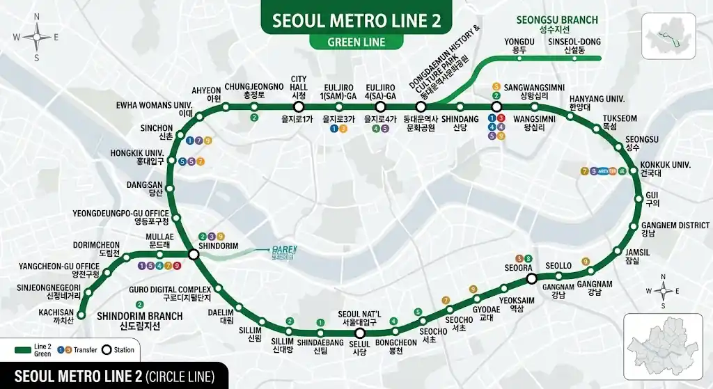
1. Line 2 Route
Line 2 is the circular line that passes through many of the busiest parts of Seoul.
It connects places that many travelers already know, such as City Hall, Jamsil, Gangnam, Hongdae, Sinchon, and Sillim.
Among seoul subway lines 2 3 4, this is the line that covers the widest range of popular districts.
That is why many visitors end up using it more than once in the same trip.
| Item | Details |
|---|---|
| Line type | Circular subway line across central Seoul |
| Main areas | City Hall, Euljiro, Wangsimni, Konkuk Univ., Jamsil, Samseong, Gangnam, Gyodae, Sadang, Sillim, Sindorim, Hongdae, Sinchon |
| Best for | Gangnam trips, Jamsil visits, Hongdae and Sinchon visits, southwest Seoul travel |
| Operation note | Includes the main loop and branch sections connected through Seongsu and Sindorim |
| Travel benefit | Many famous districts are connected on one line, so route planning is simpler |
Line 2 works well on days when several neighborhoods are included in one schedule. A route such as City Hall in the morning, Jamsil or Gangnam in the afternoon, and Hongdae in the evening is easier to manage when Line 2 is the base line.
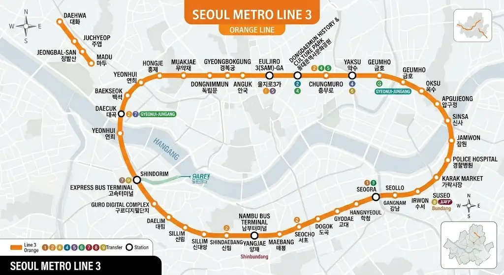
2. Line 3 Route
Line 3 is easier to understand when it is seen as a line running from the northwest area into central Seoul and then down toward southern Seoul.
It connects palace and Jongno areas such as Gyeongbokgung, Anguk, and Jongno 3-ga, and it also reaches Apgujeong, Express Bus Terminal, Yangjae, and Suseo.
Among seoul subway lines 2 3 4, Line 3 is especially useful when one day includes both sightseeing and southern Seoul travel.
It is one of the easiest lines to use for Bukchon and palace-area plans.
| Item | Details |
|---|---|
| Line type | Northwest-to-southeast line through central Seoul |
| Main areas | Gupabal, Yeonsinnae, Hongje, Gyeongbokgung, Anguk, Jongno 3-ga, Euljiro 3-ga, Chungmuro, Apgujeong, Sinsa, Express Bus Terminal, Gyodae, Yangjae, Suseo |
| Best for | Gyeongbokgung visits, Bukchon routes, Jongno travel, Apgujeong access, Express Bus Terminal access |
| Route character | Mixes sightseeing areas, residential districts, and business areas |
| Travel benefit | Very convenient for walking routes around Anguk, Bukchon, and palace areas |
A day built around Bukchon Hanok Village and Anguk Station fits Line 3 very well. Gyeongbokgung, Anguk, and Jongno 3-ga are linked in one flow, so the travel order is easier to plan without extra backtracking.
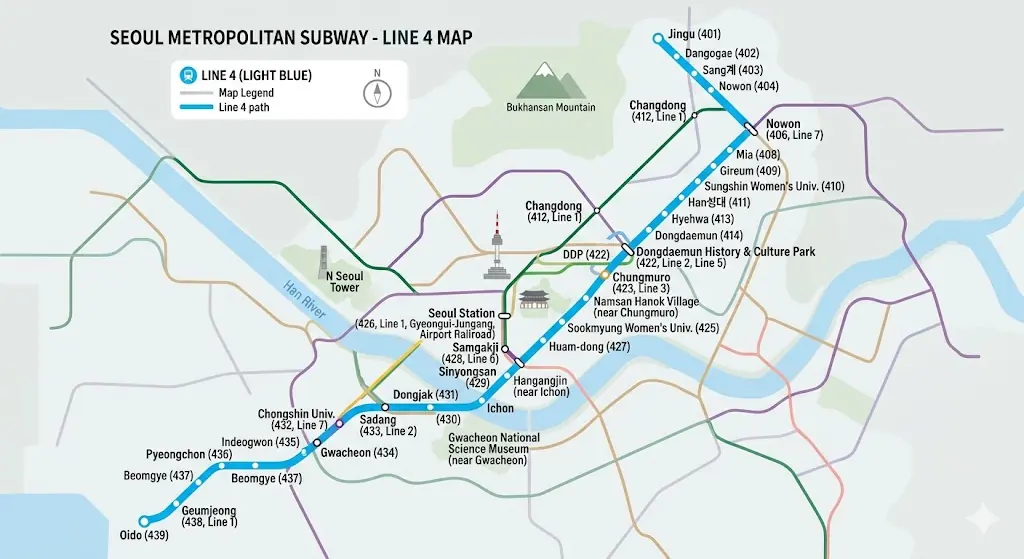
3. Line 4 Route
Line 4 runs from the northeastern side of Seoul through the center and then down toward the south. It includes stations that many visitors actually use, such as Nowon, Hyehwa, Dongdaemun, Myeongdong, Seoul Station, and Sadang.
Among seoul subway lines 2 3 4, Line 4 becomes especially useful when the destination is very clear.
It is a practical line for Seoul Station access, Myeongdong visits, Dongdaemun shopping, and Sadang transfers.
| Item | Details |
|---|---|
| Line type | Northeast-to-south line through central Seoul |
| Main areas | Nowon, Chang-dong, Suyu, Hyehwa, Dongdaemun, Dongdaemun History & Culture Park, Chungmuro, Myeongdong, Seoul Station, Samgakji, Ichon, Sadang |
| Best for | Seoul Station access, Myeongdong shopping, Dongdaemun visits, Daehangno trips, Sadang transfers |
| Route character | Strong access to central Seoul and useful for longer cross-city trips |
| Travel benefit | Easy for moving from Seoul Station into central tourist areas |
After arriving at Seoul Station, travelers heading to a hotel in Myeongdong often find Line 4 simple to follow. It also works well for a schedule that includes Hyehwa, Dongdaemun, and then a move back toward Seoul Station.
4. Key Transfer Stations
There is no need to memorize every station on the map first. It is more useful to learn where Lines 2, 3, and 4 connect to each other.
Once these transfer points are clear, the seoul subway map starts to feel much more manageable.
This is the most practical way to read seoul subway lines 2 3 4 for actual travel.
| Transfer station | Connected lines | Why it matters |
|---|---|---|
| Euljiro 3-ga | Line 2, Line 3 | One of the most useful transfer points in central Seoul |
| Chungmuro | Line 3, Line 4 | Helpful for moving between Myeongdong, Euljiro, and Jongno |
| Gyodae | Line 2, Line 3 | Important for Gangnam-area movement |
| Sadang | Line 2, Line 4 | Major connection point for southern and southwestern routes |
| Dongdaemun History & Culture Park | Line 2, Line 4, Line 5 | Useful for Dongdaemun shopping and city movement |
| City Hall | Line 1, Line 2 | Important for central Seoul access |
| Jongno 3-ga | Line 1, Line 3, Line 5 | Very useful for Jongno-area routes |
| Seoul Station | Line 1, Line 4, Airport Railroad and others | Important for airport links and city entry |
It helps to remember four stations first: Euljiro 3-ga, Chungmuro, Gyodae, and Sadang. These stations make it much easier to connect Jongno, Myeongdong, Gangnam, and southern Seoul without getting lost in the full map.
5. Best Line by Destination
Travelers do not use every line in the same way. It is easier to choose one base line after deciding where the main destination is.
That approach makes seoul subway lines for tourists much easier to understand, and it also makes seoul subway lines 2 3 4 feel less confusing.
The map becomes more practical when each line is matched with a real destination group.
| Destination type | Best line to check first | Reason |
|---|---|---|
| Gangnam, Jamsil, Hongdae, Sinchon | Line 2 | Popular districts are broadly connected on one line |
| Gyeongbokgung, Anguk, Bukchon, Apgujeong | Line 3 | Strong link between palace areas, Jongno, and southern Seoul |
| Myeongdong, Seoul Station, Dongdaemun, Hyehwa | Line 4 | Fast access to key central destinations |
| Gangnam to Jongno | Line 3 or transfer from Line 2 to Line 3 | Easy to choose based on exact stop |
| From Seoul Station into the city | Line 4 | Convenient for central tourist entry |
For a day that includes Bukchon and Gyeongbokgung first, then Myeongdong later, seoul subway lines 2 3 4 are easier to read when Line 3 is used as the starting line in the morning. After that, Chungmuro becomes a useful point for moving onto Line
“Check out other travel information”
▶ Seoul Subway Line 1 Map, Ticket Buying Methods, and Tourist Apps in One Guide
▶ How to Get to Everland from Seoul: The Easiest Routes and Travel Time
▶ SEVENTEEN WORLD TOUR NEW ENCORE Ticketing Membership Verification to General Sales
▶ Waterbomb Seoul 2026 Dates, Venue, and Entry Rules in One Clean Read
6. How to Read Seoul Subway Lines 2 3 4
It is much easier to start with the destination, then check which line it belongs to, and finally confirm the transfer station if one is needed.
This method works well for people seeing seoul subway lines 2 3 4 and the seoul metro map for the first time.
It is also a practical way to understand the best Seoul subway lines for sightseeing without making the route harder to follow.
| Step | What to check | Why it helps |
|---|---|---|
| 1 | Choose the destination first | The destination matters more than the full network |
| 2 | Check whether it is on Line 2, 3, or 4 | This gives a base line right away |
| 3 | If a transfer is needed, check Gyodae, Sadang, Chungmuro, or Euljiro 3-ga | These are the main connection points |
| 4 | Group nearby sightseeing areas by one line | This makes the route easier to follow |
| 5 | For longer trips, check large stations such as Seoul Station or Sadang again | This helps prevent route mistakes |
A schedule that includes City Hall, Euljiro, Dongdaemun, and Myeongdong often involves both Line 2 and Line 4. In that case, checking City Hall, Dongdaemun History & Culture Park, and Chungmuro first makes the overall route much easier to follow.